
MARITIMEPOSTS.COM — JAVA SEA, September 14, 2026 — The Java Sea has once again become the scene of a maritime tragedy after Virgo Transport 8 encountered severe weather while sailing from Surabaya toward Banjarmasin on Sunday, September 13, 2026.
The passenger vessel developed a dangerous list before eventually capsizing in waters around Masalembo, triggering a large-scale search and rescue operation involving Indonesian maritime authorities, military personnel, police, rescue specialists, vessels, aircraft, and hundreds of personnel.
The latest reports available on September 14 said the vessel had been carrying 243 people, with 108 people rescued, six confirmed dead, and 129 people still missing as search teams continued operations across the Java Sea.
The tragedy has once again placed Masalembo Waters at the center of Indonesia’s maritime safety discussion, raising a question that extends beyond the latest accident: why does this particular maritime environment repeatedly challenge vessels and rescue operations?
The answer, however, should not be sought in myths about supernatural forces or an Indonesian version of the Bermuda Triangle, but in the interaction between geography, weather, waves, currents, vessel operations, human decisions, maritime traffic, and emergency response.
A Maritime Crossroads in the Java Sea
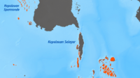
The Masalembu Islands are located in the Java Sea, north of Madura and within an important maritime environment connecting Java, Madura, Kalimantan, Sulawesi, and other parts of the Indonesian archipelago through busy sea routes.
Indonesia depends heavily on maritime transportation because thousands of islands must remain connected through passenger ferries, cargo vessels, fishing boats, and other forms of shipping that sustain mobility and regional economic activity.
The Java Sea therefore functions as more than a geographical body of water, because it operates as a major transportation corridor carrying people, vehicles, commodities, energy resources, and economic activities between different regions.
This strategic importance also creates exposure to risk, because the greater the volume of maritime traffic, the greater the number of vessels potentially exposed to changing weather, navigation challenges, mechanical problems, and human error.
Masalembo should consequently be understood not as an isolated patch of ocean, but as part of a much larger maritime transportation system where environmental and operational risks can intersect.
Virgo Transport 8: The Latest Warning
The latest incident involving Virgo Transport 8 occurred on September 13, 2026, when the passenger vessel sailing from Surabaya toward Banjarmasin encountered severe weather in the Java Sea.
According to the latest reports, 243 people were aboard the vessel, while 108 people had been rescued, six people had died, and 129 others remained missing as Indonesian authorities continued the search operation.
Reuters reported that strong waves struck the vessel’s starboard side, causing the ship to develop a significant list before eventually capsizing, while rough sea conditions also complicated rescue efforts.
These details immediately place the tragedy within a physical maritime context, although they should not yet be interpreted as a complete explanation of why the vessel ultimately capsized.
A full investigation must examine the relationship between wave direction, vessel stability, loading conditions, vehicle distribution, cargo movement, navigation, vessel condition, crew response, and other operational factors.
This distinction is critical because severe weather can trigger an accident, while the severity of its consequences may depend upon how resilient the vessel and its surrounding safety system are under extreme conditions.
Tampomas II: The Disaster That Became History
Long before Virgo Transport 8 entered the headlines, the name Masalembo had already become associated with one of Indonesia’s most notorious maritime disasters involving a passenger and vehicle ferry.
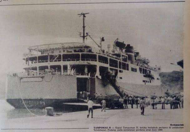
On January 27, 1981, KMP Tampomas II caught fire and eventually sank in the Java Sea while sailing from Jakarta toward Ujung Pandang, now known as Makassar, causing hundreds of deaths.
Historical accounts differ regarding the exact number of people aboard and the final number of victims, but the disaster became a major national tragedy and generated widespread concern about maritime safety.
Tampomas II was a Roll-on/Roll-off, or Ro-Ro, passenger and vehicle ferry, a vessel category that requires particular attention to vehicle loading, cargo securing, fire prevention, stability, evacuation procedures, and passenger safety.
The tragedy generated questions about vessel condition, maintenance, emergency procedures, regulatory oversight, and the broader institutional framework governing passenger transportation by sea.
More than four decades later, the historical significance of Tampomas II remains relevant because Indonesia continues to depend on passenger ferries to connect communities separated by thousands of kilometres of ocean.
Mutiara Sentosa I: Another Ferry Disaster
The Masalembu area appeared again in Indonesia’s maritime accident history in May 2017, when KMP Mutiara Sentosa I caught fire while operating in waters around Masalembu, East Java.
Reports at the time said five people died, while other passengers were initially reported missing as rescue teams worked to evacuate people from the burning vessel under difficult maritime conditions.
The incident was significant because Mutiara Sentosa I was also a Ro-Ro ferry, meaning that passenger transportation and vehicle transportation occurred within the same operational environment.
Ro-Ro vessels have distinctive safety considerations because large vehicle decks can create particular challenges involving fire, cargo securing, vehicle movement, ventilation, evacuation, and vessel stability during emergencies.
The accident demonstrated that a maritime disaster does not necessarily begin with sinking, because fire, flooding, propulsion failure, cargo movement, structural damage, or listing can each develop into a life-threatening emergency.
Mutiara Sentosa 2: Another Warning in 2026
The Masalembu story became even more striking in 2026 when KMP Mutiara Sentosa 2 suffered a major fire in early August while operating in waters off Sumenep, East Java.
The incident occurred only weeks before the Virgo Transport 8 disaster, providing another reminder that passenger vessels operating within this broader maritime region can face serious emergencies.
Reports indicated that hundreds of people were aboard the vessel, while rough sea conditions complicated the evacuation and subsequent movement of survivors toward safer locations.
The incident demonstrated another important characteristic of maritime emergencies: rescuing people from a vessel is only one stage of the operation, because transporting survivors through difficult sea conditions can create additional challenges.
The sequence is important because it shows that maritime safety cannot be measured solely by whether rescuers eventually reach an accident site, but also by whether the entire emergency-response chain functions effectively.
Why Weather Matters So Much
The Java Sea is not permanently dangerous, and thousands of vessels cross its waters safely every year, but maritime conditions can change rapidly enough to transform an ordinary voyage into a serious emergency.
Wind direction, wave height, wave period, ocean currents, atmospheric conditions, and the vessel’s heading can combine to produce sea states that are considerably more challenging than a simple forecast number might suggest.
For a vessel, the relationship between the direction of incoming waves and its own heading can be particularly important because waves approaching from the side may produce substantial rolling forces.
When those forces interact with an already compromised loading condition or reduced stability margin, a vessel may become increasingly vulnerable to excessive heel or listing.
This is why investigators examining Virgo Transport 8 will need to understand not only how high the waves were, but also how the vessel responded to those waves under its actual operational condition.
Currents Make the Rescue Problem More Difficult
There is another factor that often receives less public attention during maritime disasters: what happens to people after they enter the water.
Survivors and floating debris do not necessarily remain close to the location where a vessel capsizes, because wind, waves, and ocean currents can gradually transport people and objects away from the original accident position.
Consequently, the search area can expand significantly as time passes, requiring SAR teams to continually reassess search patterns and probable survivor locations.
Modern search and rescue operations increasingly rely on environmental modelling, vessel tracking, weather information, satellite data, and other technologies to estimate where people and debris may have drifted.
This makes oceanographic knowledge an important part of maritime safety, because understanding currents and surface movement can directly influence the probability of locating survivors within the critical early hours.
The Geography of Distance
Masalembo’s geographic position also matters because emergency response at sea is fundamentally different from emergency response on land, where rescue vehicles can often travel directly toward an accident.
At sea, rescuers must consider distance, vessel speed, wave conditions, visibility, weather, fuel capacity, search patterns, communications, and the probability that survivors have already drifted away from the vessel’s last known position.
Aircraft can dramatically accelerate search operations, but aircraft and helicopters also have operational limitations when weather, visibility, wind, or sea conditions become hazardous.
Rescue vessels face another limitation because they must physically travel through the same sea conditions that may already have caused the original emergency.
The Virgo Transport 8 operation demonstrated this difficult reality, with rough seas complicating rescue activities while Indonesian authorities deployed vessels, aircraft, divers, and specialized search teams.
In other words, the same environmental conditions that create the maritime emergency can simultaneously restrict the ability of rescuers to respond quickly and safely.
Is Masalembo Really Indonesia’s Bermuda Triangle?
The nickname is attractive because it is memorable and immediately communicates the idea of a dangerous maritime location, but journalism should be careful not to turn historical accidents into supernatural narratives.
There is no scientific basis for claiming that Masalembo possesses mysterious forces comparable to the mythology associated with the Bermuda Triangle.
A more useful explanation is that Masalembo lies within an important maritime corridor where weather, vessel operations, traffic density, geography, and emergency-response challenges can converge.
The area does not need supernatural explanations to become dangerous, because strong waves, unstable vessels, difficult navigation, limited shelter, and expanding search areas are already sufficient to create serious maritime risks.
The more responsible question is therefore not whether Masalembo is cursed, but whether its known environmental and operational risks are adequately understood and incorporated into Indonesia’s maritime safety system.
The Real Question Is Not “Why Masalembo?”
The more useful question is what combination of environmental, technological, operational, and institutional factors makes maritime accidents in this region potentially so consequential.
That question shifts the discussion from folklore toward governance and asks whether weather information reaches ship operators quickly enough to support effective operational decisions.
It also asks whether captains possess sufficient authority and flexibility to delay departure or alter routes when weather conditions deteriorate beyond acceptable safety limits.
The discussion must also consider whether passenger and vehicle loading is consistently monitored, whether safety equipment is functional, and whether crews receive adequate emergency training.
Another important question concerns the ability of regulators to conduct effective oversight throughout a vessel’s operational life rather than focusing primarily on inspections and documentation at particular moments.
These questions are not intended to assign blame before an investigation is completed, but rather to identify weaknesses that could be addressed before another emergency develops.
From Accident Investigation to Prevention
The history of Tampomas II, Mutiara Sentosa I, Mutiara Sentosa 2, and now Virgo Transport 8 suggests that Indonesia should examine maritime accidents not only individually but also as a pattern.
Every accident has its own immediate circumstances, yet recurring incidents may reveal systemic vulnerabilities that cannot be fully understood through isolated investigations.
A comprehensive maritime safety strategy should therefore compare accident histories, weather conditions, vessel types, routes, loading practices, emergency responses, communication systems, and the performance of regulatory oversight.
If several incidents repeatedly involve severe weather, passenger ferries, vehicle decks, stability problems, evacuation challenges, or difficulties reaching survivors, those recurring characteristics should become part of national risk assessment.
The objective should not simply be to determine what went wrong in one accident, but to understand what conditions allowed a relatively contained problem to escalate into a mass-casualty emergency.
That approach transforms accident investigation from a reactive exercise into a preventive instrument capable of improving Indonesia’s maritime governance.
Technology Can Change the Equation
Indonesia now possesses technologies that were unavailable when Tampomas II sank in 1981, including satellite communications, Automatic Identification System monitoring, improved weather forecasting, digital navigation, drones, aircraft, and increasingly sophisticated SAR coordination.
These technologies can significantly improve situational awareness, but technology alone cannot eliminate maritime risk or replace competent human judgment.
A sophisticated weather forecast has limited value if the information does not reach the bridge in time or if operational decisions fail to respond appropriately to changing conditions.
Similarly, an AIS signal becomes useful only when authorities and operators can interpret unusual vessel movements and respond quickly when a potential emergency becomes apparent.
Satellite imagery, oceanographic modelling, and digital communication systems are therefore most effective when they are integrated into a coordinated maritime safety architecture connecting ships, ports, regulators, meteorological agencies, and rescue organizations.
The future of maritime safety should consequently focus not simply on acquiring more technology, but on ensuring that information moves rapidly from sensors and forecasting systems into effective operational decisions.
A Culture of Safety
Ultimately, the Masalembo question is also a question about safety culture within Indonesia’s maritime transportation system.
A genuine safety culture means that delaying a voyage because of dangerous weather is understood as responsible decision-making rather than an operational inconvenience that threatens schedules or commercial targets.
It means technical problems can be reported without fear, loading procedures are treated as safety-critical activities, emergency drills are conducted seriously, and passengers receive clear information about what to do when an emergency occurs.
It also means regulators, operators, crews, port authorities, meteorological agencies, SAR organizations, and passengers understand that maritime safety is a shared responsibility.
This principle becomes particularly important for Indonesia because the country cannot simply reduce its dependence on maritime transportation, with millions of people continuing to rely on ships and ferries for everyday mobility.
Masalembo as a Maritime Safety Laboratory
Perhaps Masalembo should therefore be viewed differently, not as a mysterious triangle but as a potential maritime safety laboratory where Indonesia can systematically study recurring risks.
Historical accident records could be combined with vessel traffic information, AIS data, meteorological records, wave modelling, ocean currents, bathymetry, vessel characteristics, and SAR performance to identify patterns that are otherwise difficult to see.
Such a database could help authorities determine whether specific seasons, weather systems, routes, vessel categories, loading conditions, or combinations of factors produce significantly elevated risks.
The information could also support decisions about where rescue vessels should be positioned, how quickly aircraft can reach the area, and where emergency reception facilities should be strengthened.
In this sense, Masalembo could become a place where Indonesia moves from simply responding to maritime disasters toward systematically anticipating and reducing maritime risk.
From Tampomas II to Virgo Transport 8
More than four decades separate Tampomas II from Virgo Transport 8, during which Indonesia has undergone enormous technological, economic, institutional, and infrastructural changes.
Communication systems have improved, maritime surveillance has expanded, forecasting capabilities have become more sophisticated, and Indonesia’s search and rescue institutions possess capabilities that were unimaginable during the early 1980s.
Yet the fundamental vulnerability remains because people still need to cross the sea, vessels still encounter difficult weather, and emergencies can still develop far from immediate assistance.
The difference between survival and tragedy can therefore depend on minutes, preparedness, decision-making, vessel resilience, emergency equipment, communication, and the ability of institutions to work together under extreme pressure.
That is why the Virgo Transport 8 disaster should not be remembered simply as another unfortunate maritime accident, but as another opportunity to examine how Indonesia manages risk in one of its most important transportation environments.
The Sea Is Not the Enemy
Masalembo is not inherently a place of mystery, and the Java Sea itself is not the enemy because the ocean is a natural environment whose risks can be understood, monitored, managed, and reduced.
The greatest danger often emerges when natural hazards meet human vulnerability, creating circumstances in which a manageable event can rapidly become a major disaster.
A strong wave is a natural phenomenon, while vessel stability is an engineering matter, navigational decisions involve human judgment, weather forecasting represents technological capacity, and rescue operations depend upon institutional preparedness.
When these elements work together, thousands of maritime journeys can be completed safely despite challenging environmental conditions.
When several elements fail simultaneously, however, the consequences can become catastrophic, particularly when hundreds of passengers are aboard a vessel far from immediate assistance.
That is the real lesson of Masalembo, and it is far more useful than any comparison with the Bermuda Triangle.
The question is not whether Indonesia can eliminate maritime risk, because no maritime nation can completely remove the forces of weather, waves, currents, distance, and human uncertainty.
The real question is whether Indonesia can anticipate risk, reduce exposure, strengthen vessel resilience, respond faster, and learn more effectively from every maritime accident.
The history of Masalembo provides Indonesia with an extraordinary opportunity to pursue precisely that objective, using decades of accident experience and contemporary technology to strengthen maritime safety.
From Tampomas II in 1981, through Mutiara Sentosa I in 2017, Mutiara Sentosa 2 in 2026, and now Virgo Transport 8, the message remains remarkably consistent: maritime safety must evolve as quickly as Indonesia’s dependence on the sea.
The sea will always have waves, weather will always change, currents will always move, and ships will always face uncertainty, but the systems protecting human life can become smarter, stronger, faster, and better prepared.
Masalembo does not need to be Indonesia’s Bermuda Triangle. It can instead become Indonesia’s reminder that maritime safety is not achieved by conquering the sea, but by understanding its risks and respecting the lives entrusted to those who cross it.