


In South Sulawesi, power was never an abstract concept; it was a logistical reality tied to water management. To rule the land, one had to master the flow of its rivers. This historical logic, reflected in the maritime codes of figures like Amanna Gappa of Wajo—who codified complex systems of trade and navigation—can be distilled into three strategic layers.
MARITIMEPOSTS.COM – The human imagination has long been anchored by the myth of Atlantis—a “super-civilization” purportedly swallowed by the sea in a single night of misfortune.
However, as a cultural historian, I find the archaeological reality far more compelling than the legend. Across the globe, sites like Dwarka in India, Heracleion in Egypt, and Pavlopetri in Greece offer tangible proof of coastal cities and ports reclaimed by rising tides and shifting earth. Even off the coast of France, 7,000-year-old stone walls stand as silent witnesses to human adaptation against the encroaching ocean.
In South Sulawesi, history is not merely a collection of stone monuments; it is a narrative written in the fluid dynamics of rivers and the expansion of seasonal lakes.
Here, the “sunken” past is found in the sediment of prehistoric bays that transformed into inland basins. To understand the rise of kingdoms, the spread of faith, and the resilience of its people, one must look past the battlefield and into the hydrological systems that dictated the boundaries of power.
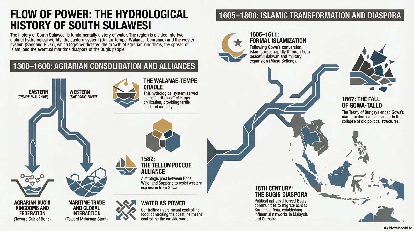
Reality 1: The Hydrological Wall—A Tale of Two Worlds
While a modern map might suggest a unified peninsula, the waters of South Sulawesi reveal a fundamental geological divide. The region is split by a “hydrological wall”—a product of tectonic structures and rugged topography—that creates two entirely distinct aquatic universes.
The Eastern system is a sophisticated network centered on the Walanae River and Danau Tempe. This system functions as a singular corridor, receiving runoff from dozens of smaller streams before flowing through the Cenranae River into the Bone Bay. Conversely, the Western system is dominated by the Saddang River, which carves its path toward the Makassar Strait.
This is more than a geographical curiosity; it is the structural boundary of history. Despite their proximity, these two systems never truly connected. This hydrological isolation fostered the development of distinct spheres of influence: one looking east toward the deep, protected waters of Bone, and the other looking west toward the global maritime arteries of the Makassar Strait.
The Cradle of Civilization was a Floodplain
The true “cradle” (rahim sejarah) of Bugis civilization lies within the Walanae valley and the Danau Tempe basin. Human habitation here stretches back 30,000 years, with ancient peoples adapting to a landscape that evolved from a prehistoric bay into the seasonal lake system we see today.
While military conquest often dominates the headlines of history, the birth of the great Bugis kingdoms—Bone, Wajo, and Soppeng—was catalyzed by the environment. Long before the 1582 formation of the Tellumpoccoe alliance (the “Three Peaks” pact between these three powers), the basin provided the three essential pillars for a burgeoning society:
- Reliable Water: A consistent source for growing communities.
- Protein: Rich fishing grounds within the lake systems.
- Fertility: Silt deposits from seasonal flooding that created exceptionally productive agricultural land.
The mastery of this floodplain allowed these societies to settle, grow, and organize into sophisticated political entities long before the first sword was drawn in the name of empire.
Reality 3: The Logic of Power—Control the Water, Control the World
In South Sulawesi, power was never an abstract concept; it was a logistical reality tied to water management. To rule the land, one had to master the flow of its rivers. This historical logic, reflected in the maritime codes of figures like Amanna Gappa of Wajo—who codified complex systems of trade and navigation—can be distilled into three strategic layers:
- Controlling Food: Mastery of the lakes (the agrarian heartland).
- Controlling Movement: Mastery of the rivers (the Walanae as a mobility corridor for internal communication).
- Controlling Trade: Mastery of the coast (access to the Bone Bay and international networks).
This philosophy is best summarized by the region’s historical wisdom:
“Who rules the river, rules the food. Who rules the lake, rules the people. Who rules the coast, rules the outside world.”
Reality 4: The Dual Path of Islam—Faith, Trade, and Politics
The transition to Islam in the early 17th century (1605–1611) was a nuanced transformation that moved along two parallel paths. The first was the peaceful path, driven by trade and the intellectual influence of the Tiga Datuk (Three Datuks): Datuk ri Bandang, Datuk ri Tiro, and Datuk ri Pattimang. These preachers found that Islamic monotheism resonated with ancient Bugis beliefs in Dewata Seuwae (the One God). Indeed, individual conversion had deep roots; Syekh Jumadil Kubro is said to have arrived as early as 1320, followed by Nakhoda Bonang in 1567.
The second was the political and military path, known as Musu Selleng (the Islamization War), characterized by the expansion of the Gowa-Tallo kingdom. This shift brought a total transformation of social life. Archaeological evidence at sites like Patunuang reveals a stark transition: from ancient traditions of cremation—where researchers found ceramics containing ash and bone—to Islamic burials oriented north-south. This era also saw the construction of iconic structures like the stone-walled Masjid Tua Tosora (c. 1621), marking the moment where local custom (adat) was woven into a global legal and spiritual framework.
Reality 5: Exile as Power—The Birth of the Bugis Diaspora
The fall of the Gowa kingdom in 1667 following the Treaty of Bungaya, and the subsequent 1679 defeat of Wajo after the siege of Tosora, represented a profound political collapse. However, in the history of this region, defeat did not lead to disappearance; it led to movement.
Refusing to submit to the VOC (Dutch East India Company) and the Bone alliance, waves of Bugis people—particularly from Wajo—chose exile over subjugation. This triggered the great diaspora, with communities settling in Siak, Johor, Indragiri, and Kalimantan.
While this was a period of displacement and trauma, it paradoxically expanded the Bugis identity. Rather than being erased, the Bugis became a powerful maritime network, building new political and economic elites across the Malay Archipelago. Their “defeat” at home effectively globalized their influence, turning the sea into a new theater of power.
History is a River, Not a Monument
The history of South Sulawesi teaches us that power is as fluid as the water systems that support it. From the ancient floodplains of the Walanae—which transformed from a salt-water bay into a life-giving lake—to the maritime networks of the diaspora, water has remained the hidden structure of authority.
As we look at our own modern landscapes, we must ask: In what ways are our environments subtly shaping the “history” we are making today? The legacy of the Bugis and Makassar people suggests that true glory does not lie in building monuments that withstand time, but in the ability to adapt and move with the “current of time.” To survive is to flow; to rule is to understand the water.